ECIL Services

Surveying Investigation


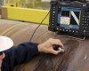


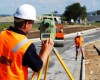

Accurate surveys and mapping techniques play a pivotal role in the development and planning of engineering projects. In recognition of this important aspect, ECIL established its own survey & mapping division in 1976. The division works in close coordination with department of Geo-informatics to cater for their mapping requirements. The professional surveyors are familiar with modern mapping technology and are capable of using Global Positioning System (GPS), total station and personal computers for data processing. The state-of-the-art software such as ERDAS Imagine, SDR Map and TRIM Map facilitate data processing to deliver quality end product to our clients.
SERVICES OFFERED
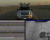
1. Mobile mapping (LiDAR and Video)
2. Static LiDAR
3.Land, boundary and cadastral surveys
4.Topographic & contour surveys
5.Cartographic surveys
6.Satellite imagery processing
7.Digital terrain modelling (DTM)
8.Digitization and scanning (raster-to-vector conversions)
9.Geographic positioning surveys, including static surveys, stop-and-go surveys, pseudo static surveys, pseudo kinematics surveys.