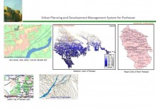
Urban Planning and Development Management System for Lasbela
BACK TO PROJECTS
Name of associated firm :
-
Project Location within Country:
Lasbela- Balochistan
Start Date:
March 2005
Completion Date:
March 2007
Project Description
The development objective of the project is to contribute to the guided urban growth pattern along with an efficient, updated urban management information system supported by an implementable urban planning and legislative framework. To attain the foregoing development objective, the following immediate objectives were assigned to the project
-
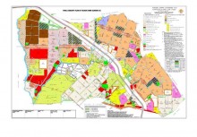
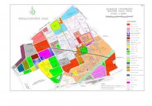
To develop an updated digital base map of District Lasbela and to develop pilot Urban Management Information System of the Uthal Town, District Lasbela on GIS platform
-
To review the previous municipal, revenue and infrastructure, land use and update the same, developing an overall framework for guided physical growth of Lasbela District for future planning & development of the area.
-
Preparation of complete legislative framework for guided urban growth
Services
Review all existing datasets.
Data collection for the development of the District Base Map and Legislative Framework which includes:
-
Updated Socio Economic Data
-
Updated Land Use of Uthal City and District Lasbela in general
-
Updated Infrastructure facilities in Uthal Town
-
Development of base map using satellite imagery and GIS techniques
-
Revise and update the written statement of an existing structure plan to include latest primary information and data, demographic socio economic, land use pattern, housing, services and infrastructure, urban environmental conditions and prospects of potential areas.
-
The revised structure plan covered the strategic land use analysis and framework, guiding policies for future urban growth for District Lasbela within a context of present and future changing in development priorities and potential needs.
-
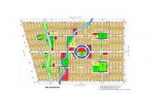
Prepare a latest map showing details of present land use pattern, infrastructure, potential future land use
-
Development of Comprehensive GIS application for Uthal Town for the District Management Offices of Lasbela Government to manage land use, infrastructure such as water supply, sewerage, electricity and telephone on scientific basis pattern, urban growth strategies & future land management strategies for District Lasbela in general.
-
Revise an updated local area action plan consists of a written statement of each proposed plan based on the updated primary data, including the strategic framework for the respective area provided in the revised structure plan along with policies and implementation framework.
-
Prioritize immediate action areas for implementation
-
Prepare legislative framework to support the structure plan in context with Urban Planning Ordinance 1975 and Local Government Act 1961 and 2000 and prepare the necessary amendments and additional legal measures to transform it into a provincial urban planning act.
-
Review and update procedures and regulations in respect of planning control and development control to frame an implementable planning and development control regulation in urban areas
-
Developed procedures and guidelines for introducing development control and zoning in Uthal Town
-
Developed procedures for introducing betterment charges along the main arteries